Rhinelander, Wisconsin to Iron River, Michigan. Thursday, May 27, 2021
Ten days. Never thought I’d be spending so long in the Badger State, but between quagmires, breakdowns, head games, and deluges, here I still was. Time to blow.
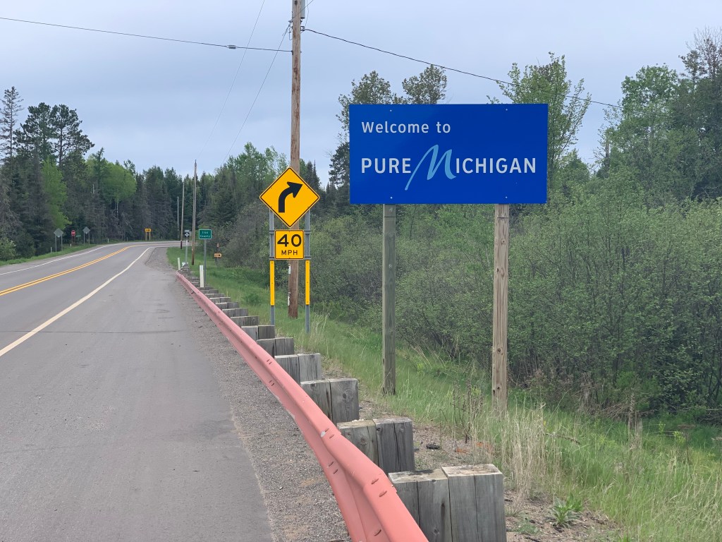
Still 52 miles to the border, and a cold, rainy headwind predicted, but with caffeine, determination, and good equipment, doable. It’s not that Wisconsin didn’t have one more curveball up her sleeve. A road construction project held me up an hour. But at 5PM, I broke free into Yooperland.
This is the Upper Peninsula, or the U.P. of Michigan, quite distinct from the lower “mitten” part, and the natives are proud of the nickname meant to be a put-down.
A sign in my motel—opps, I caught myself in the mirror
Same way Notre Dame is proud to be the Fighting Irish, Newfoundlanders embrace Newfies, and the colonials were OK with being Yankee Doodle Dandies. I found those last 10 miles to be beautiful, with well-kept farms and smooth roads. I was also delighted to see a little bit of home, US highway 2.
An old friend
I find the US highway system much more compelling than the soul-less interstates. Route 66, dripping with Americana, starts right at the Buckingham Fountain in Chicago, and it was tempting just to hop on and follow Steinbeck’s Mother Road all the way to the Santa Monica pier. Route 1 wends its legendary way from Fort Kent, Maine to Key West. On this trip, I have frequently crossed Route 6, which starts in Provincetown and takes you to Bishop CA, via the Loveland Pass in CO; and Route 20, America’s longest, from Boston to Newport OR.
But I hadn’t seen Route 2 until today. I have cycled most of it as it cuts through New England, it comes very close to my front door, where we call it Williston Road. But the Great Lakes take a huge bite out of it, there is a hiatus until it restarts on the Upper Peninsula and continues all the way to Washington State. The part through eastern Montana, paralleling the Great Northern rail line, is called the High Line. I love that. Anyway, I texted Jane to come join me for dinner, I was just down Williston Road.
Hey, it’s almost Memorial Day, why is it so freezing out? It went down to 29° overnight. The motel clerk said this is not unusual. The Upper Peninsula is actually north of the Vermont-Canadian border, and far from the moderating oceans, instead surrounded by the frigid Great Lakes. People are still skiing here, they tell me. Great, and I’m going to try to do the highpoint on Saturday. I forgot my snowshoes.
Reminds me of a joke my dad used to tell about the Kiki bird. The Kiki bird lives in the Arctic, and got its name because it’s often seen shivering and saying “ki-ki-ki-Christ, it’s cold!”
Distance 62 miles, 1,861 total. Time 8 1/2 hours with stops. Elevation gain 1,703 feet
Tomahawk to Rhinelander, Wisconsin. Wednesday, May 26, 2021
A biblical reference, and even though I’m an atheist I felt like Noah, with all this rain. A milestone for me, since this was exactly how long my Camino walk lasted two years ago, so today I have surpassed my longest trip ever.
I was slow getting going. I overslept, still sleep deprived, and didn’t get up until almost 9. This motel does not serve breakfast, so I had purchased one of those eight packs of individual boxes of cereal last night, it seemed to take forever to open and eat them. Missy, the motel owner, showed me some of the other themed rooms that she had, including one full of antique truck photos, and another with early rock ‘n’ roll albums. She really is injecting some personality into this motel.
Howard, my walking buddy from South Ridge, called and we traded pep talks. Finally got going around noon, and sure enough the wind had shifted. Still, it was a pleasant 18-mile ride into Rhinelander, which was where I had hoped to go yesterday before the thunderstorms hit. Suddenly, I heard a distinctive ping from my rear wheel, and my heart sank. Every long-distance cycle tourist knows that sound, a spoke breaking. I guess the wheel-truing I got in Chicago, not to mention the weight I’ve lost, wasn’t enough to keep this from happening.
It could’ve been worse, it was much more likely that something like this would happen when the wheel was under stress, like in that quagmire two days ago. Fixing it then would’ve been a disaster, with the mosquitoes swarming. This time, I was fortunate enough to be right by the Rhinelander visitor center, a modern, welcoming facility that let me make the repair indoors, in comfort. Still, it took almost an hour.
The spoke was fixed, but the wheel still had a wobble, and I knew it ought to be trued and tensioned again, perhaps in a place that wasn’t so busy. The visitor center people suggested Bike and Boards, a shop just a couple of miles down the road. Sure enough, Al, the owner, was very helpful. He was by himself, but it was misleading to say that he wasn’t busy. Bikes are all the rage now, with everybody desperate to get outside again after the pandemic. Still, he made the time to adjust my wheel, and give me lots of tips about riding locally. To top it off, he wouldn’t take any money for his trouble. I gave a big tip to a local sports club that he was sponsoring.
All of this burned up almost 3 hours, and I had hoped to go an additional 24 miles to Eagle River. Sounds like a replay of yesterday. No storms threatening this time, but the headwind had intensified to 20 mph, the shoulder of the main road was inhospitable, and the back roads were 4 miles longer.
I should apologize for all this talk about shoulders and winds, must get pretty boring for someone who is not into bicycle touring. Definitely feels like I’m in the weeds. Suffice it to say I bitterly realized that Rhinelander was as far as I was going to get, once again taking two days to reach a place I’d hoped to get to in one.
But once again, life made lemonade from lemons. Today’s easter egg was Mark, the desk person at the Rhinelander Days Inn, who told me some of the town’s claims to fame. The most intriguing was the mythical beast, the Hodag. The story was so fantastical I’ll just give you the link. https://en.wikipedia.org/wiki/Hodag
It puts Vermont’s “Sidehill Wampahoofus” to shame. Mark had fun reading the blog, and figured I’d love the story. He was right. He even gave me a lapel pin!
My very own Hodag!
Mark also saved me from embarrassment, or worse, down the road. He corrected my pronunciation of the local delicacy “pasties” to use the short, rather than the long “a”. Talk about dodging a bullet.
I’ve said it before, but it bears repeating. The real highpoints of this trip are the people.
Distance 27 miles, 1,799 total. Time 5 1/2 hours with stops. Elevation gain 732 feet
It was only a matter of time before I had a post with this title.
After yesterday‘s drama-queen mudfest, I needed a low-key day. It rained on and off all morning, keeping me cooped up in this lovely cabin, editing yesterday’s long post with anemic WiFi. I sleep better in old fashioned beds, this has a headboard and a footboard. Still, the sunrise over Bass Lake was gorgeous enough to get me up and sit on the dock. I ate most of my motel swag from yesterday, and went down to say goodbye to my trail angel, Cathy.
Can you believe she’s six years older than me?
But she wasn’t done with me. Despite my protests, she served me a “second breakfast” of farm fresh eggs and bacon, and we chatted with more of her friends. It was 1:30 before I got out.
I had to backtrack the twelve miles to Spirit Falls, but a tailwind got me there in 45 minutes. Then it was time for my weekly session with my therapist (we discuss life transition and family issues) but the road was so smooth and traffic-free, and the wind noise so minimal with that blessed tailwind, that we could do the whole session while I dialed off another 14 miles. The thing about highpoints is, once you’ve done them, everywhere else is downhill. Before I knew it, I was in the next town, Tomahawk, and pulled over to a Senior Center bench (I qualify, right?) and studied the situation. Should I go another 24 miles?
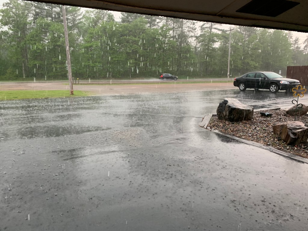
It was tempting. The wind was at my back, it would shift tomorrow. But there was a severe thunderstorm watch, only 15% chance, but still. At that moment I got phone calls from Anne and Jane, and suddenly it was an hour later, 4:30.
Perhaps I’ve said this before, back in my glory days it would’ve been a no-brainer. But the clouds looked threatening, and I did not want to get caught between towns. I settled on a motel 6 miles down the road, and five minutes after I arrived I saw I’d made the right decision.
This doesn’t capture the lightning, which was everywhere
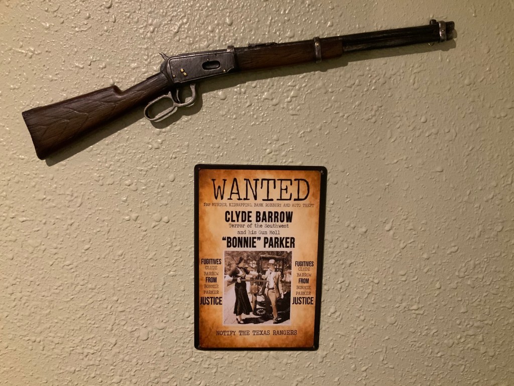
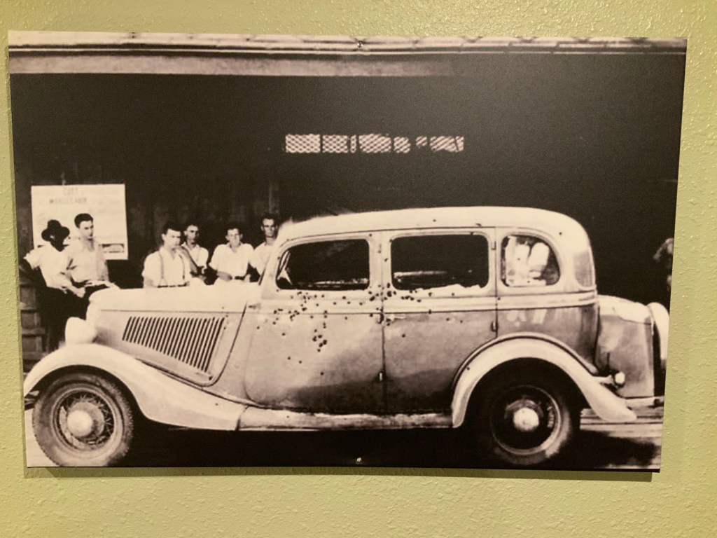
To make my choice even sweeter, the motel, a decidedly non-chain unit called the Motel Nokomis, had a couple of Easter eggs. I was the only guest, and the configuration reminded me of the “12 rooms, 12 vacancies” line from the movies. Not to worry, my shower was uneventful. On that ghoulish vein however, these photos were on the walls.
The death car
What a hoot! I mentioned earlier this was not only a highpoint tour, it was a rubbernecking-America’s-dark-places tour. As it happens, the Bonnie and Clyde ambush site is five miles from Louisiana’s highpoint, no way am I going to miss it. Missy, the motel proprietor, chose the room at random for me. Or did she?????
I suppose I should mention where I’m headed now. Mt Arvon, the highpoint of Michigan, in the Upper Peninsula, about the same height as Timm’s Hill, but deep in the woods in a tangle of logging roads; my buds have told me it’s tricky to find, even with GPS. I have no intention of a repeat performance of yesterday. It’s about 4 days away, let me post this and study the logistics very carefully.
Distance 33 miles, 1,772 total. Time 3 1/2 hours with stops. Elevation gain 593 feet
Poured all night, boy was I glad it I wasn’t camping. There would be a four-hour lull between the morning rain and afternoon thunderstorms, where I hoped to squeeze in today’s ride.
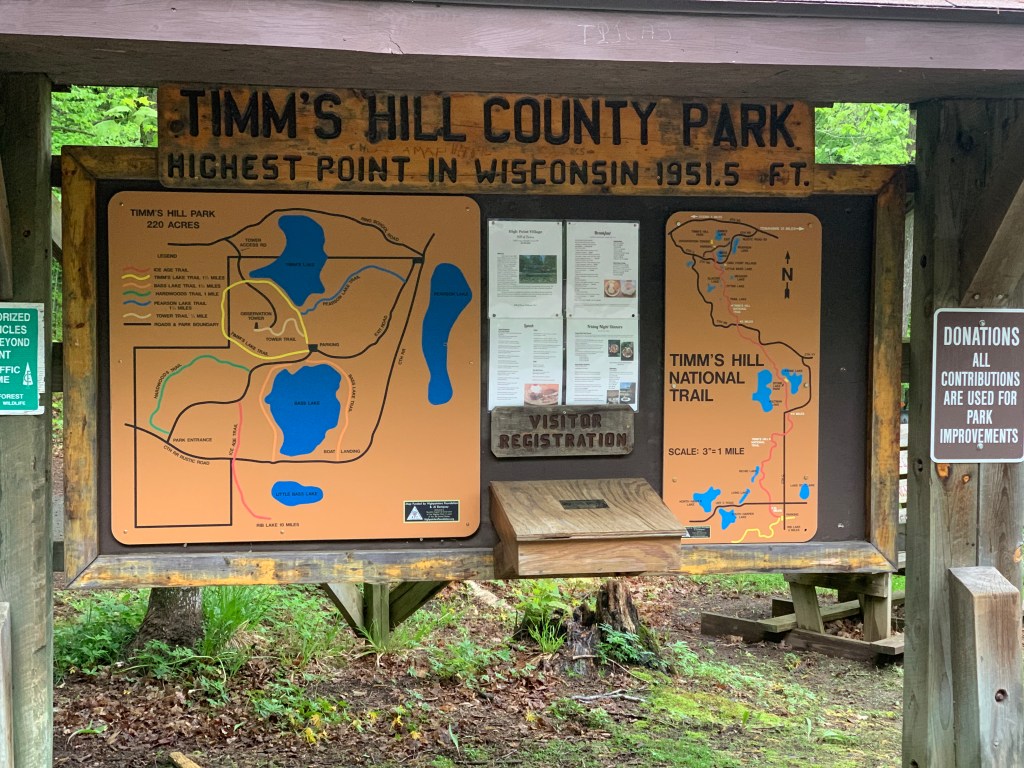
I had taken me too long to get here, but at least today was going to be easy. Just 45 miles to Timm’s Hill, the highpoint of Wisconsin. Once again, I had a choice of highways versus back roads; the back roads “hypotenused” across the square corners of the highways, and saved me about 5 miles. A no-brainer.
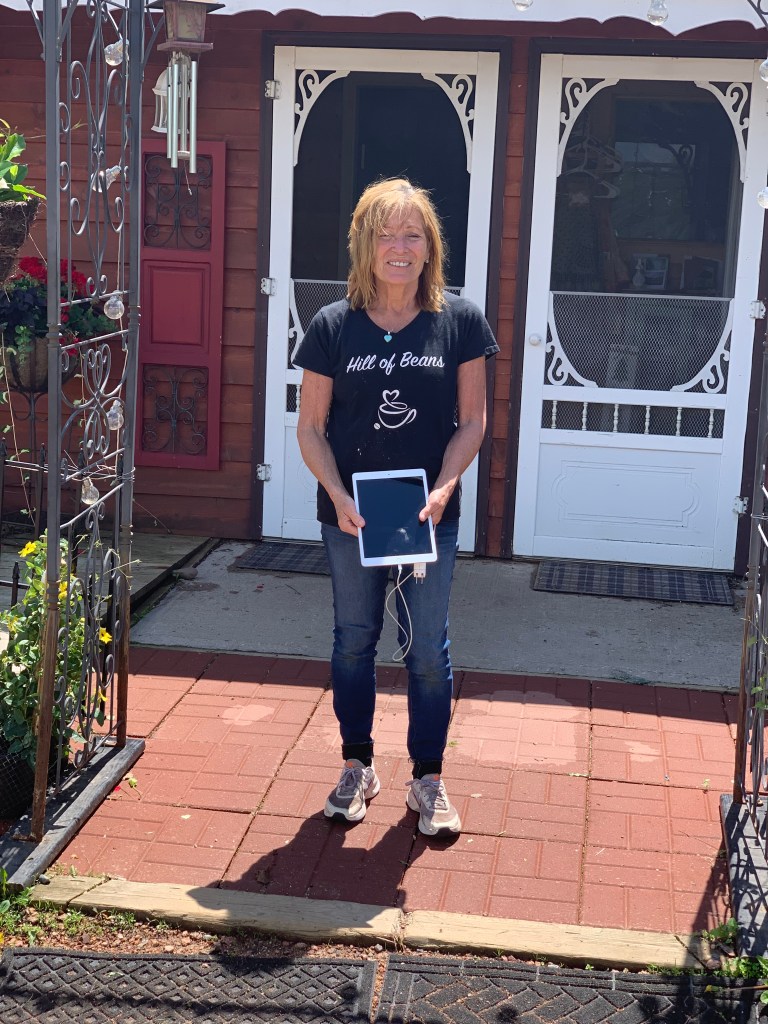
No camping and only one lodging choice in the area, a group of cabins called High Point Village. I called them, and got the impression that they were technically closed on Mondays, but Cathy, the owner, said that a cabin should be free. I gave her my usual story about the unpredictability of bike touring, I didn’t want to reserve, but I would call her once I knew I was going to make it. Her restaurant, Hill of Beans (love it) was definitely closed, she said she might be able to cook something for me but I said, no, I don’t want to infringe on your only day off, I’ll just load up on the motel swag—fruit, cellophane-wrapped muffins and Danishes, granola bars.
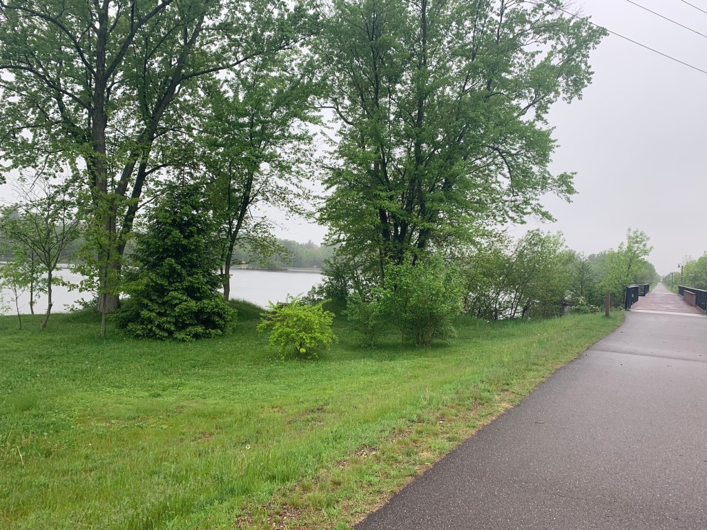
Things went bravely at first. Little Merrill turned out to be quite nice for me—a good motel, a no-fee ATM, a decent Mexican restaurant, easy laundry, nice hot tub, that pretty courthouse—and this morning, a sweet bike path called River’s Bend to guide me out of town, following the Wisconsin River.
Those first 15 miles sped by, and I was feeling great. Then all hell broke loose.
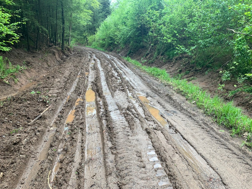
The road turned to dirt. I don’t mind dirt roads so much, I was bound to encounter them and have the right tires, but after all that rain they were pretty soft and dropped my speed from 13 to 8 mph. Not the biggest deal, but I was trying to get in before the thunderstorms. I briefly considered backtracking to the highways, but thought, no, RideWithGPS knows what it’s doing, I’ll just press on, the dirt can’t last too long, right?
Wrong. The roads kept deteriorating, my speed dropped to 4 mph, and by the time I realized my mistake I was in for a penny, in for a pound. The app allows me to download the route so I’m not dependent on a cell signal for guidance. Trouble is, the route is all it has. Sure enough, I had no cell signal at all to give me a bailout route, just the blue route line in a blank sea on the screen. All I could do was press forward.
It begs the question, why didn’t I have a paper map for times like these? In Wausau I checked at the bike store and a Barnes and Noble—nothing. Nobody uses paper maps anymore. I could hear Burt Reynolds, laughing at me.
The crummy road I was on veered right, but the app said to go straight. Huh? There was no straight. Wait a minute, a faint track through the brush did lead to a wire gate. and a sign, Private Property. You’ve got to be kidding. The road will go around, no? Without a signal, there was no telling. No choice but to duck awkwardly under that cable, and trespass. I hoped Farmer John wasn’t waiting ahead with a shotgun.
No Farmer John, but a couple of large birds—turkeys? herons? geese?—blocked the weedy track I could only walk through, and didn’t want to back down. They kept honking at me, agitated. Was I invading their roost? They were at least four feet tall, with sharp beaks. Stupid to be afraid of a couple of birds, but I was exhausted, a little scared, swarmed with mosquitoes, and trespassing. I was way behind schedule, the thunderstorms were coming and would turn this mess of back roads into a real quagmire. Well, I guess I could camp here if I have to, but there was no dry ground in sight, and that’s before the storms.
OK, one bar of cell service. Enough to get a set of coordinates, to pass on to Jane if I needed a rescue. I tried to call her, but the one bar gave out. So I pressed on warily, the birds made a fuss but eventually flew away. Wow, they were spectacular (I heard later they were sandhill cranes). In better times I would have tried to get a picture and identify them, but now I was bent on survival.
In half a mile, I ducked under another wire gate, at least I wasn’t trespassing any more. Back on the “roads”, but here’s a picture of what they were like.
This wasn’t the worst of it
All I could do was awkwardly drag my bike through the ruts and puddles. I was hungry and dehydrated, I knew my three water bottles weren’t enough for overnight, but the only water around was in those puddles.
Eventually passed another closed gate, and gathered that everything I had been doing for the past few miles was closed. There was a maintenance building for the Town of Corning, locked and empty, but at least a sign of civilization.
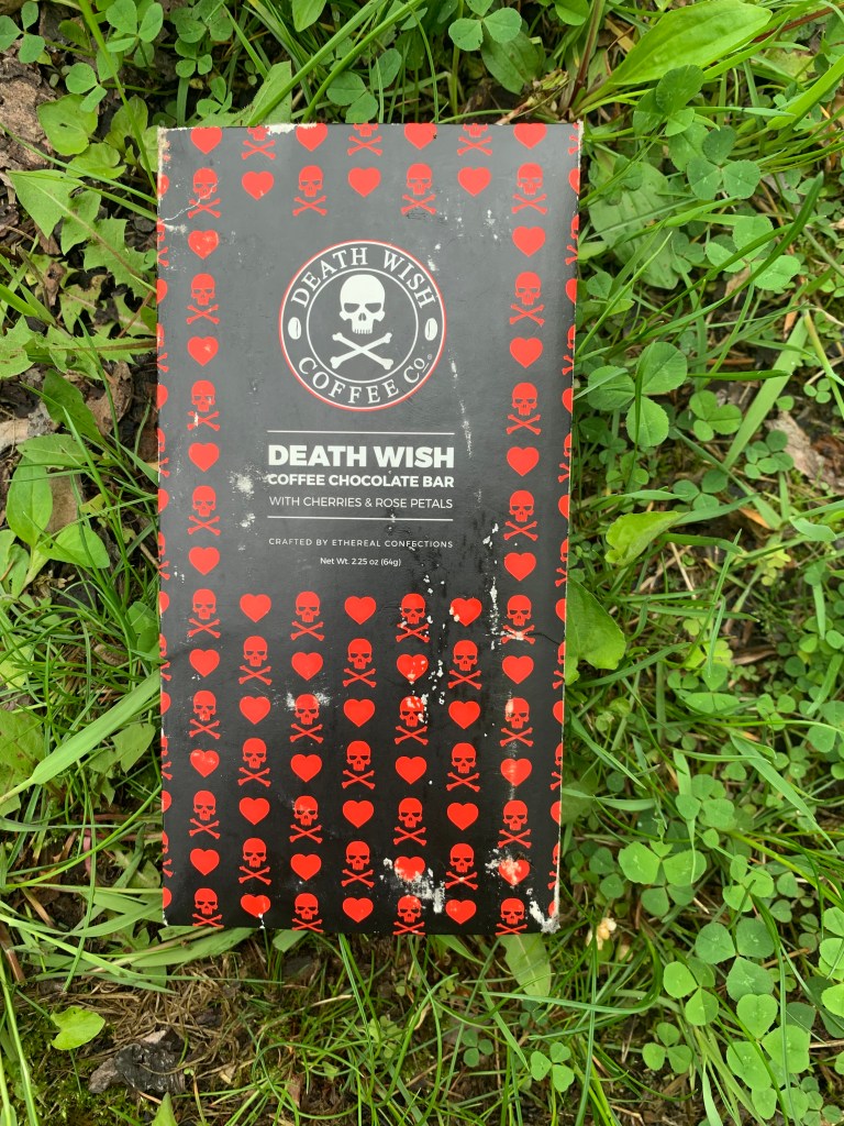
There was also, thank God, a water pump out front. If the deluge hit, I could at least huddle under an eave. The water tasted funny, but I downed 2 liters and hoped there was no giardia. I crouched on a stump, wolfed down some of my motel swag, and found a chocolate bar that Steve Youker from my first warmshowers in Glens Falls, 5 weeks ago, had given me.
Death Wish. Yeah, that’s about right. But it tasted great, and the caffeine restored my moxie. If you’re still following the blog, thanks Steve! You might have saved my life.
After another mile of muddy ruts, I came upon a real dirt road. Still soft from the rain, but at least I could ride again. No signal, still no map to guide me, but a sign said Spirit Falls, 12 miles. I remembered that was a town on the highway I would have taken if I hadn’t hypoteneused.
Words can’t describe the relief I felt. See you later, RideWithGPS. In 12 miles I was back on the highway, no signal but there was a paper map (YES) on a bulletin board that showed it was about 12 more miles to Timm’s Hill. By now it was pouring, and already almost 4PM, but no thunder and the caffeine had definitely kicked in. The highway was so smooth, good shoulder, easy hills, almost no traffic—why on earth hadn’t I chosen that option from the beginning?
My odometer again stopped working in the rain but I had that map in my mind. As I always do when I approach these minor high points, I looked for an impressive view of it from afar. Nothing but forested hills, and after about an hour I saw a tiny sign, Hill of Beans Restaurant, pointing off to the left. No other indication I was close to my destination.
In two more miles I was at Highpoint Village. It was now 5:30 PM.
Adorable, with a view of Timm’s Hill across Bass Lake, but signs saying Closed. I’d tried to call repeatedly from the road, but no signal. Great. Well, I could run up the highpoint and go another 6 miles to the next town, where supposedly there was a motel. No way to call and make sure.
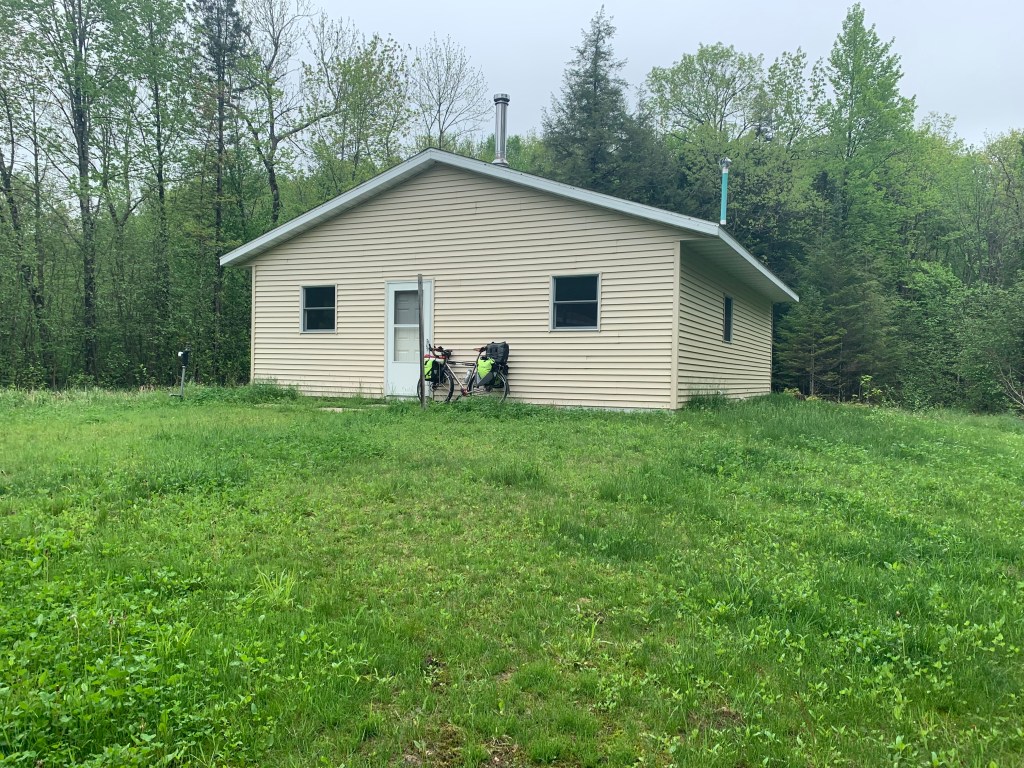
Hope against hope I found a back door open, and called out “hello?” To my immense relief, Cathy, the owner appeared. A “trail angel” if ever there was one. She’d wondered about me, her son had spotted a bedraggled biker on the highway. Sure, I could stay there. And sure, she could make me a meatball sandwich, a salad, and she had some root beer. I protested weakly, no this is your one day off, but how could I turn her down? I’ve rarely had a meal that tasted so good.
She loaded my blog (she had WiFi) and checked out my podcasts as I wolfed down my meal. She had many stories to tell, much more impressive than mine, of highpointers that had come through. One was a guy who had met someone in a bar who needed a kidney transplant. Right away he became a kidney donor, and was biking across the country as he recovered from the surgery. Wow.
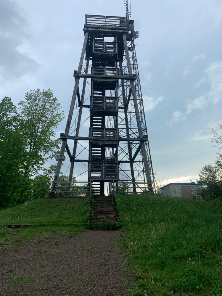
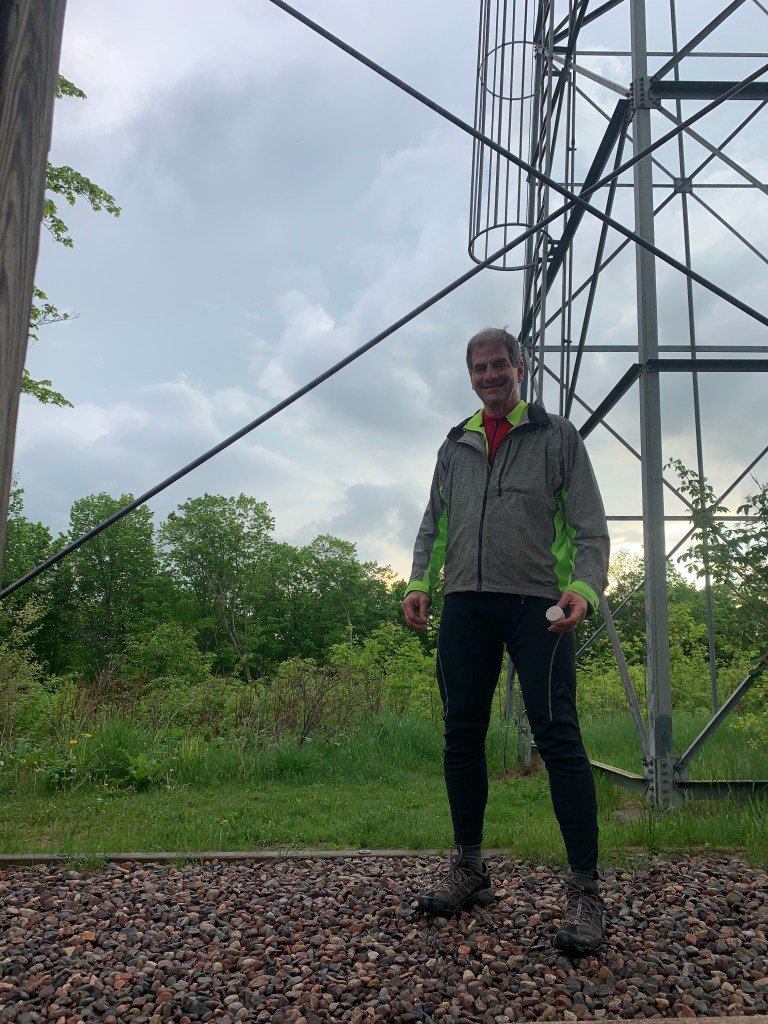
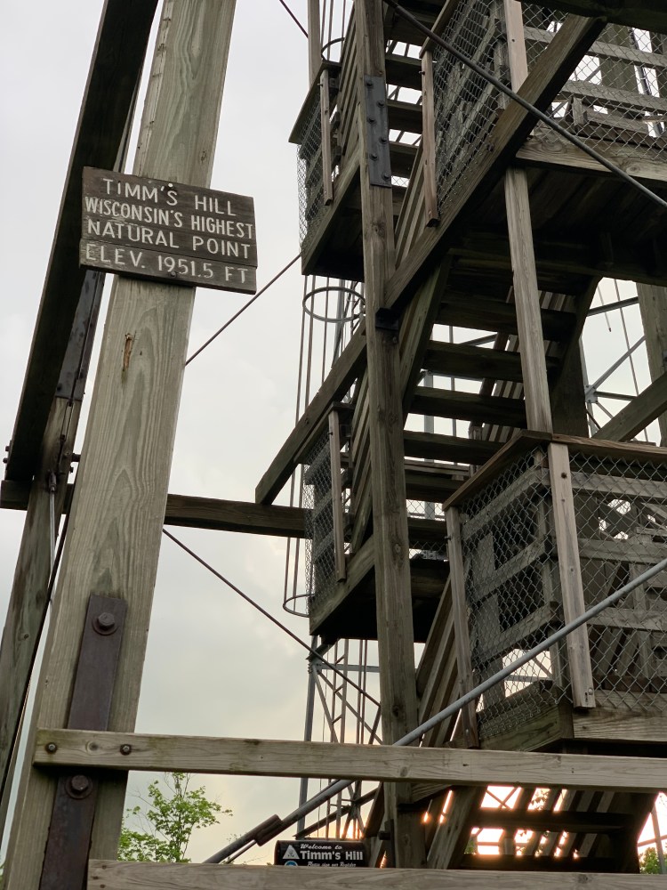
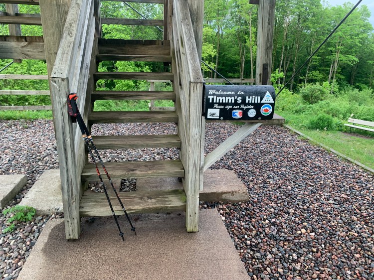
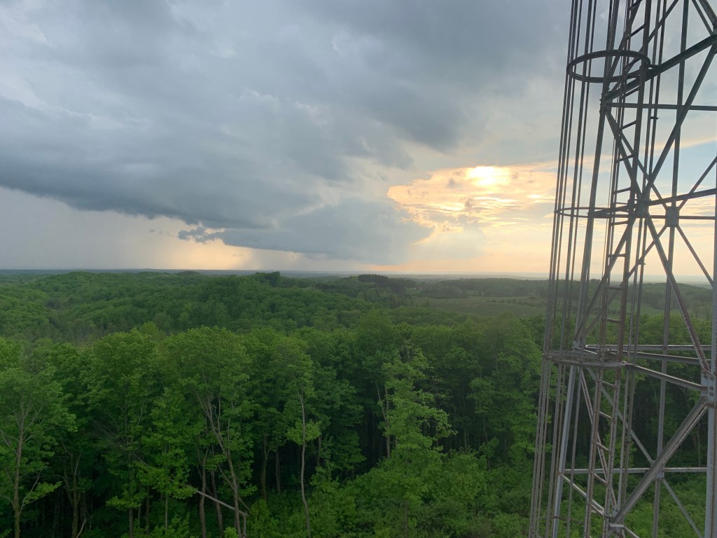
Now fully revived, I still had time for the highpoint. A two mile loop circled the lake, and went up the 145 foot climb to the towers. I had the whole park to myself.
The older tower behind the new
Dad’s ashes in my left hand
Timm’s Hill resonates with me, Tim the Beaver is my college mascot, the school name spelled backwards. The original fire tower is higher, but has a scary steel ladder, and not the best choice with thunderstorms around. Let’s face it, I shouldn’t be on a mountain at all. But the lower wooden tower had fine views anyway, my first vistas from any highpoint this trip.
Uh oh. Better get off the tower.
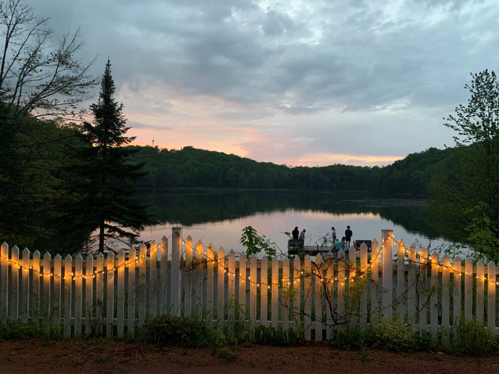
I did the obligatory ash-scattering, and signed the log in the mailbox, while dodging intermittent cloudbursts. Highpoint # 32 for me, my 10th from sea level. Back at the lodge, at sunset, I marveled at how pretty this place is.
You can see the highpoint fire tower to the left, and other guests on the dock
Still, this was supposed to be one of the easy ones. Jane is right, I catastrophize everything. Campbell Hill had the “Momma said there’ll be days like this” drama, Hoosier Hill had the Rain Man debacle, and now this. The next two highpoints are known for being trickier. I wonder what adventures lie ahead. One thing for sure, no more dirt roads, if I can help it.
Distance 51 miles, 1,739 total. Time 9 hours with stops. Elevation gain 1,992 feet
Wittenberg to Merrill, Wisconsin. Sunday, May 23, 2021
So even though I wound up bailing to the highways yesterday, I was determined to try the back roads again. This time I lasted about 3 miles. I got dumped back on that unimproved railroad, this time a bit firmer, but still was only doing 7 mph. Today, it was State Highway 29 that beckoned. Seemed fairly quiet at first, shoulders were not as good as US 45 but not bad, but gradually the highway got busier and wider and pretty soon I realized I was on a four-lane limited-access superhighway.
The thing was, it was great. I didn’t want to get off. The shoulder was now fully wide and in good shape, the rumble strip protected me from the speeding traffic, which never got close, and a tailwind had me going 15mph average, even with the hills. I kept looking for that “pedestrians and bicycles prohibited” sign you see at freeway on-ramps, but I wasn’t on an on-ramp, having “grandfathered in”. I wondered if a cop would pull me over, but none did. I made the 33 miles to Wausau in just over 2 hours.
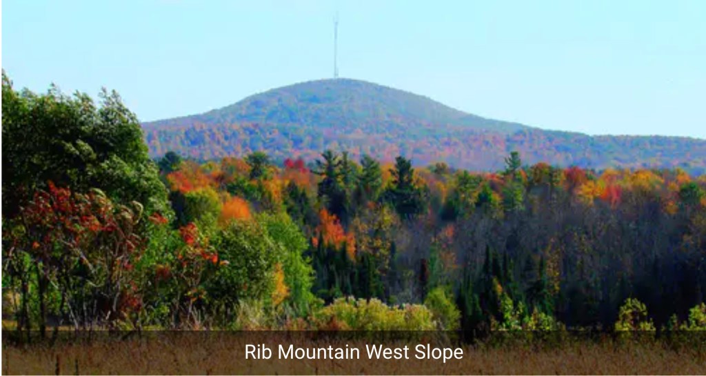
About 10 miles out, I saw something I hadn’t seen in over a month—a mountain. I had to blink to be sure, it wasn’t that high but it was a genuine mountain! I wanted to take a picture but didn’t dare stop and give Smokey a chance to bust me.
I knew what it was: Rib Mountain. Long thought to be Wisconsin’s highpoint, it was eventually found to be 9 feet lower than Timm’s Hill, but much more prominent, in how it rose over the surrounding landscape. It loomed 741 feet above Wausau, and had one of the nation’s first ski areas, built by the CCC in 1937. When I got off the highway, it was obscured by clouds, so I’ll have to scrape the web for a picture.
I pulled into Mickey D’s just ahead of a downpour, had to linger for an hour. Next was a stop at the local bike shop (I hate to pass these by, they’re so few and far between) to top off the tires, repair my handlebar tape, and buy a beanie to protect my scalp from the sun. Zach was very helpful. There is a road up Rib Mountain, but the rain shower burned up the time I had. She was not to be denied, however. I was back to the RideWithGPS-selected back roads, and the road I was following seemed to climb a wall ahead, a “rib” of Rib Mountain. As I approached,I thought surely the navigator would route me around, bu no, we were going straight up it. It was only a quarter mile long, but one of the steepest grades I have ever encountered. In WisCONsin! I had to get off and push, and stop to rest 4 times in that quarter mile. Legend has it that those are Paul Bunyan’s ribs, buried on that mountain.
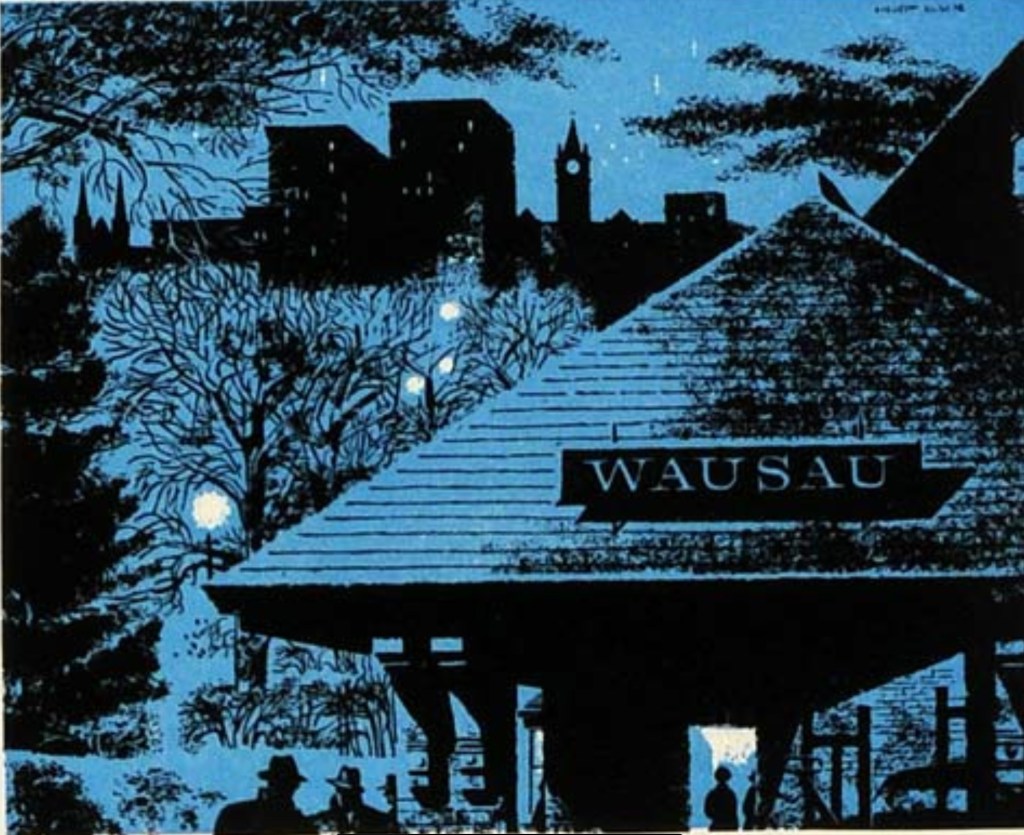
Am I the only one for whom the name Wausau tickles the mystic chords of memory? This logo, which I haven’t seen in 50 years, is as fresh in my mind as yesterday.
Wausau Insurance Company logo
I had to look it up to find out why. Wausau Insurance was one of the earliest advertisers for 60 Minutes, which we watched constantly when it began. That logo would flash on the screen each week. There’s something about that image—comforting and scary at the same time. Homey but exotic, the name evoking the wild north. “USA” is buried in the name. The dark shape of the depot evocative of the Auschwitz death gate. Brrr, creepy.
I already knew the depot had long since been torn down, so no sense going into town to look for it. Chippewa Falls, which every Titanic fangirl knows is the hometown of Jack Dawson, is nearby; I didn’t go there either. Instead after that ridiculous climb I zigzagged north and west, going over many smaller hills, the flat days are definitely over. Again, I hoped to get close to Timm’s Hill, but by 4PM I still had 36 miles and the wind was cold, the air heavy with threatened rain; I wimped out after 54 miles. Merrill offered a choice of a cheap motel or a campground, and I wimped out a second time. I hate packing a wet tent. The town at least had a cool courthouse.
Lincoln County Courthouse
Distance 54 miles, 1,688 total. Time 7 hours with stops. Elevation gain 1,796 feet
New London to Wittenberg, Wisconsin. Saturday, May 22, 2021
I seem to be on a The Doors kick. Mr. Mojo Risin’ is an anagram of Jim Morrison. LA Woman was the last song he recorded.
My buds could tell I was in a funk, and Brian sent me a clip of Jimmy Smith’s Got My Mojo Workin’. It was just what I needed.
I set off, determined to take back roads this time. They were working fine for a while, but were definitely rougher, hillier, and more meandering. They also led me past a lot of homes with dogs. None turned out to be a problem, but it required that extra vigilance.
A sign up ahead said the road was closed for bridge repair. Ugh, not this again. Fortunately, a kindly couple said that ATVs were able to get through, and, with a little walking through the mud, so did I. Finally, I found myself on an abandoned railroad track, not yet made into a rail trail. It was beautiful but buggy, soft and partially overgrown, and I could only make about 5 mph.
US Route 45 was just over there, so I gave it a try. Much better. As opposed to the state highways, the shoulders were wide, smooth, and without rumble strips. The grading was better, the hills shallower, and nobody would let their dog out from a home next to a busy highway. And so the back-roads-versus-highways conundrum continues.
After weeks of flat terrain, I was mildly piqued to have to deal with hills. Then it occurred to me: if you’re going to be visiting highpoints, Poindexter, you’re going to get hills. Get over it.
The wind had shifted to a 10 mph headwind, which gets old after a while. At Wittenberg, the choice was to stop there or go another 30 miles. Thunderstorms predicted overnight, so camping not a great option. I opted to stay at the Best Western here, and had a great meatloaf dinner for $18 at the local truck stop. Kind of disappointed that it took me two days to do what I had hoped to do in one.
Crashed early, but was surprised by a FaceTime call from Jane and 4 friends, who really bucked me up. Thanks guys. Another mojo infusion. Maybe this will shake off my ennui.
Distance 41 miles, 1,634 total. Time 6 hours with stops. Elevation gain 1,040 feet
Menasha to New London, Wisconsin Friday, May 21, 2021
The Vrabec‘s house was beautiful, the bed comfortable, but I only slept five hours. The news about Ben really shook me up. Steph had to get out early, but we still had time for a nice breakfast, and I was able to leave the house before 9, very early for me.
The weather was slated to change, so I tried to get as far as I could before that. It caught up to me in New London: rain, thunderstorms with hail predicted. Normally I would ride anyway, but today I was creeped out. My ultimate destination, Timm’s Hill, the highpoint of Wisconsin, was 160 miles away by the direct roads, much longer if you stuck to the back roads and bike paths. I decided to try the main roads. They were safe enough, but the shoulder was only two feet wide, with a rumble strip on one side and soft gravel on the other. Trucks were generally considerate as they sped by, but some came quite close. It was OK if you maintained a firm grip on the handlebars, but it wound up being quite exhausting. When I stopped in New London, it took five minutes from my pulse to drop below 120. I have an EKG feature on my watch, I wondered if I was in atrial fibrillation, but it turned out only to be benign sinus tachycardia. I was just nervous.
I kept thinking of Ben, and his accident. At least he had someone to call for help. New London was only 26 miles in; I had wanted to go 67, to Wittenberg. As I rode the last 2 miles to the motels, I kept wondering, should I stop here or keep going? The storms would stop overnight, I could get to bed early and get a jump on the highways before they got busy next morning. The wind would not be as favorable, though.
You know what clinched it for me? My odometer had stopped working in the rain. Damned if I was going another 40 miles and not get “credit”.
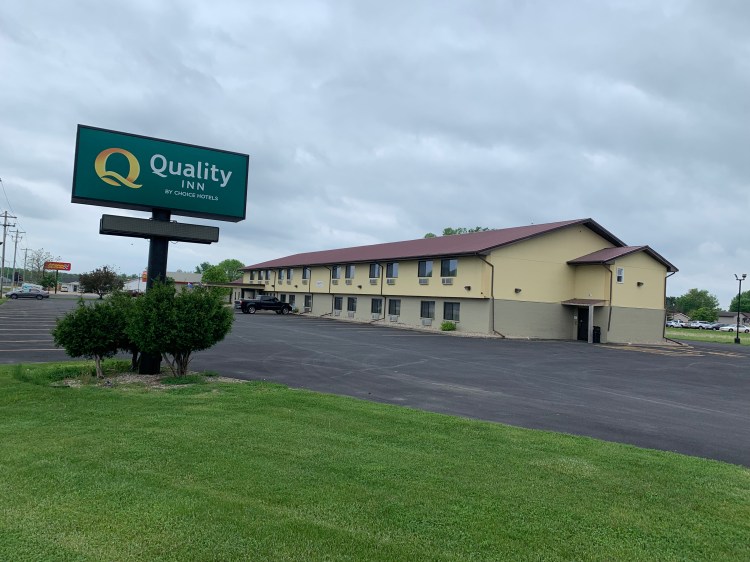
The cheaper motel, a Quality Inn, did not look very prepossessing, but the inside had been recently renovated. The manager asked me to use the back entrance for my bike. I had waltzed right into the marble entryway of the Chicago Magnificent Mile Marriott, but at the New London Quality Inn, they had me use the service entrance.
I did have a nice soak in their hot tub, and felt better. I might wind up losing a day, and the storm never got as bad as predicted, but it still felt like the right choice. I had a nice long talk with sister Sarah, whose class at Holy Cross graduated today, and marked the end of her three year term as head of the Environmental Studies department. She starts her sabbatical in July. Congratulations!
Eden to Menasha, Wisconsin. Thursday, May 20, 2021
This was one of those days which was so pleasant, you almost feel guilty. It’s not supposed to be this easy. When is the other shoe going to drop?
There were no hills to slow me down this time. After lingering in that “garden of Eden” of the Breezy Hill campground, it was an easy swoop down to Fond du Lac, at the southern tip of Lake Winnebago.
My family will tell you I’m fond of milk, but I don’t need THAT much
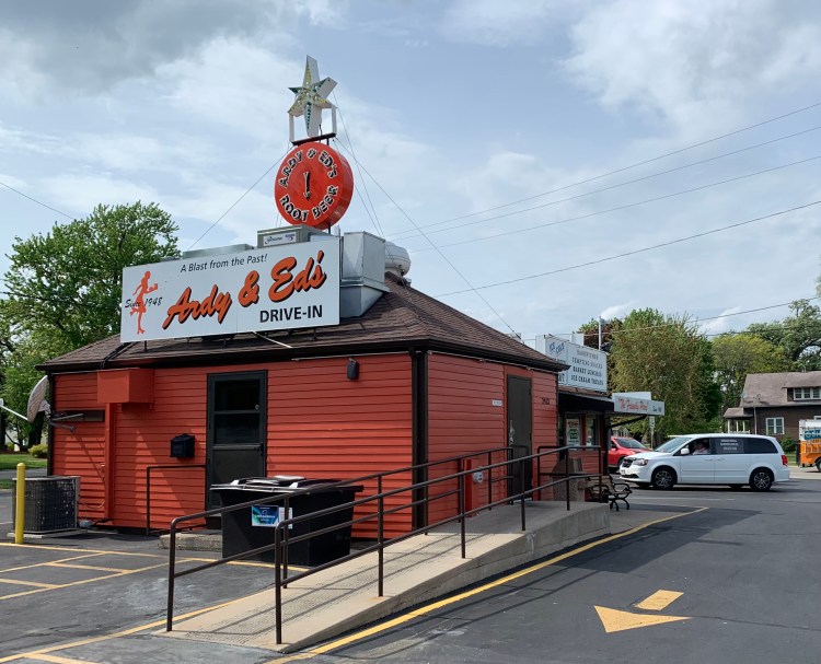
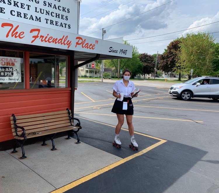
From there a ruler straight, beautifully paved road with a strong tailwind blew me into Oshkosh, famous for toddlers clothes, an annual air festival, and an old fashioned drive-in restaurant, where Courtney brought me my drink on roller skates.
Right out of American Graffiti Thanks, Courtney!
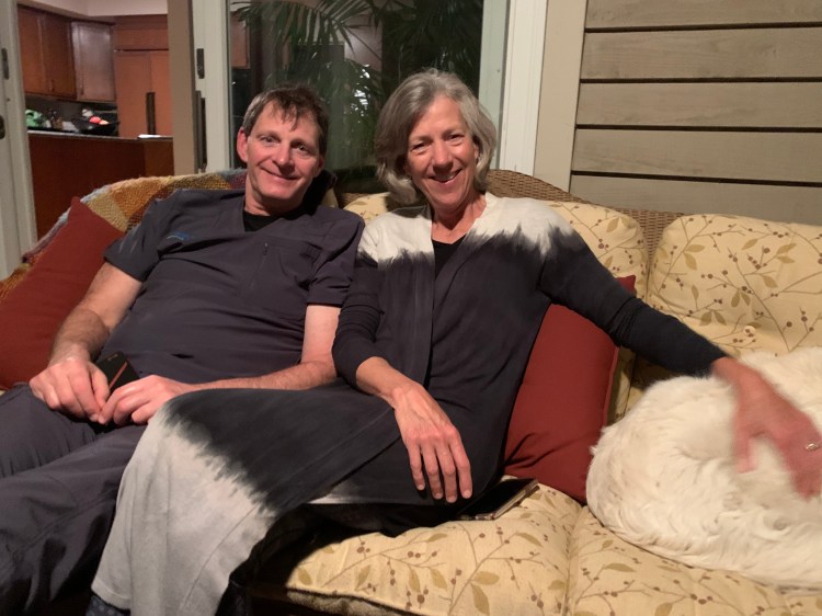
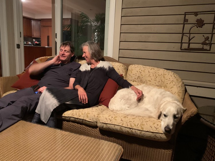
The wind continued to push me the length of the lake to the Vrabec’s lovely lakeside home. Steph, an environmental sciences teacher, pampered me with laundry and a sumptuous shower, and we met Mike, an ophthalmologist specializing in LASIK surgery, for dinner at a great Mexican place in town. Mike has climbed Kilimanjaro, Mont Blanc, and Mt. Elbrus, the highest mountain in Europe, is a pilot and avid cyclist. I had such fun talking to them I lost track of time and kept them up. I have to remember, not everyone is retired!
Mike and StephNot to mention their adorable English cream retriever, Murphy
The bliss was undercut by some dispiriting news. Christine texted to let me know that Ben (this was the couple from Namibia I rode with last week) had suffered a head injury. His front wheel apparently collapsed while swerving to avoid traffic. He was taken to the local ER where head and neck scans were negative, but he has to follow up with a neurologist in Davenport. I talked to them both, he seems fine, but they realize how catastrophic this could have been. They are rethinking whether it is wise to continue. I asked them to call me anytime with updates or questions. Oh, my heart just goes out to them.
Although I’ve never felt healthier, it underscores the precariousness of my own situation. I’m three years older and traveling alone. I promised them, and Jane, to be extra special careful.
Distance 46 miles, 1,565 total. Time 5 hours with stops. Elevation gain 368 feet
Milwaukee to Eden, Wisconsin. Wednesday May 19, 2021
As soon as I crossed into Wisconsin yesterday, I realized it was a bikers’ paradise. The quality of the bike path improved immediately, and drivers and dogs were notably nicer.
It was hard to leave Annie after a great night’s sleep. We lingered over breakfast, talked for hours about old times, and I had fun playing with her adorable golden retriever, Paddington.
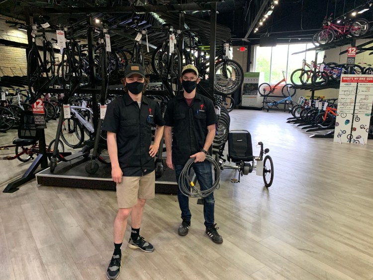
I needed bike gloves, and Annie directed me to Erik’s nearby. The guy with the keys didn’t arrive till 11:30, but is was worth the wait. What a store. I looked around, surely there’s something I’ll need, I’m not going to see a shop like this for weeks, but all I really needed was the gloves. Here are two of the great guys who helped and chatted with me.
Next on the agenda was to head to my friend and colleague Mike Vrabec near Appleton, he has a lovely house on the shores of Lake Winnebago. Just over 100 miles, so a two day trip. I’ve come to trust my navigator app, RideWithGPS; I just punch in the destination and come along for the ride. Sure enough, I was directed to a series of rail trails, so smooth, flat, and safe.
Nine years ago I talked Jane and Hope into doing the C&O Canal with me, sweetening the pot by promising to stay in B&Bs each night. I was enthralled with the beauty and history, but Jane said, eh, it’s just a boring green tunnel.
Well even I could admit that these rail trails could be a bit boring. Ruler-straight, flat, generally with train tracks on one side and a string of power lines on the other; yeah, but so stress-free. Today had a nice tailwind, so no wind noise. I took the opportunity to call friends, this time my good buddy Caroline, and we talked and talked. Next was a FaceTime call to Jane and the family on the Cape, I could see my friend David shucking Wellfleet oysters, and they could see me sweating over the handlebars. The miles just sped by, interrupted only by a banana split in West Bend.
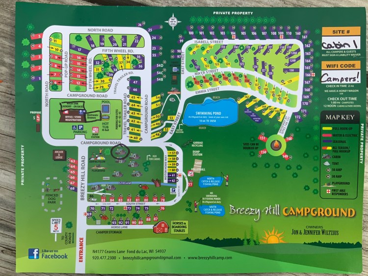
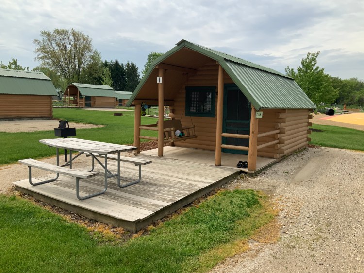
The weather was nice enough that I decided to try camping. I called ahead, and Sara, the manager at Breezy Hill Campground in Eden, heard my story and offered me a cabin at tent-site rates. I guess I’ve perfected the pathetic routine enough that people are offering me upgrades before they even see me!
I say these rail trails are flat, but they do go over hills, it’s just that the grade is so gradual you notice only when you see your speed go down and up. Also, you do go slower when you’re yakking constantly on the phone. So these easy tailwind miles took longer than I bargained for, and I didn’t get in to the campground until almost 8. I loaded up on dinner and breakfast stuff at a quick stop 3 miles before, and felt like a bag lady, with a laden grocery bag hanging from the handlebars. I had fun watching the sunset over dinner from my campsite, and catching the end of Ordinary People.
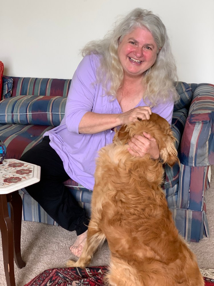
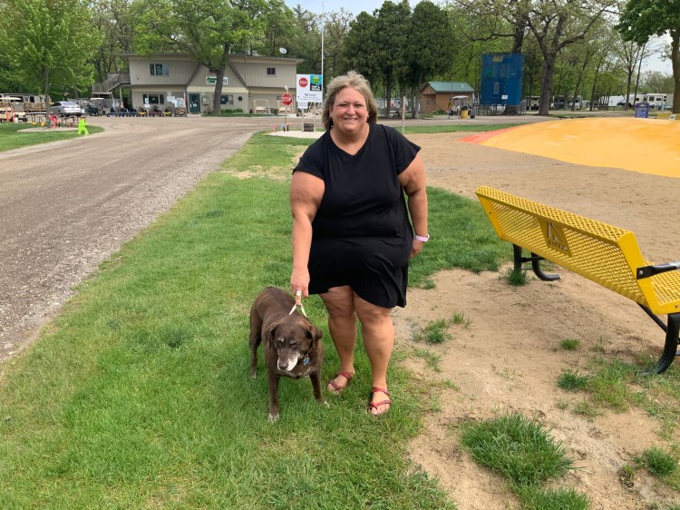
In the morning, I was able to thank Sara, and her dog Isabelle. Her brother Jon, the owner, gave me a Chapstick for the road. It’s these small kindnesses that make the trip so special. They have lavished a lot of care on their campground, and I was very comfortable in my cabin for 30 bucks.
Sara and Isabelle“Roughing it “
Distance 62 miles, 1,519 total. Time 7 1/2 hours with stops. Elevation gain 1,212 feet
Zion, Illinois to Milwaukee, Wisconsin Tuesday, May 18, 2021
Today’s entry will be short and sweet, just like the day was. With little fuss, my navigator guided me along a series of bike paths and quiet roads up the shores of Lake Michigan to visit family in Milwaukee. There was even a gentle tailwind to help. With very little traffic to worry about, I was able to have long conversations on the phone, particularly with my sister Anne, who has been such a comfort and support along this ride.
The city of Kenosha had been in the news lately, and I was a bit concerned, but it was actually beautiful, with a dazzling waterfront. I wish I could’ve gotten a picture, but it would’ve meant breaking off the phone conversation. So too was the case with Racine, which I’d heard could be fairly gritty. It was just a pleasant town on the lake, and a place for lunch.
Before I knew it, I was approaching the the towers of Milwaukee, a town I had never seen. I was soon wrapped in family warmth, from my cousin Ann, along with my Aunt Miriam and her husband Dick, who are in a lovely nursing home. Ann made me a great steak dinner, and we talked for hours in her apartment overlooking the lake. What a delightful day. I’m getting spoiled.
Distance 55 miles, 1,457 total. Time 7 hours with stops. Elevation gain 932 feet